Armed Force of Malta :
Maltese maritime authority, in charge of the Maltese SAR Service.
Armed Force of Malta :
Maltese maritime authority, in charge of the Maltese SAR Service.
Automatic Identification System :
The AIS is a maritime transponder, used in VHF frequency for identification of ships, navigation marks and coastal stations for safety of navigation.
AISs are designed to be capable of providing information about the ship to other ships and to coastal authorities automatically.
The information published on the open source websites such as Marine Traffic or Vessel Finder rely on the coastal relays, which get the AIS signal from the ships by VHF. The VHF frequencies have a limited range of 30 to 50 miles. If a ship is more than 30-50 miles from a shore-based relay antenna, the ship is not visible on the websites anymore, but the AIS is still ON and visible by all stations located 30-50 miles around the ship.
AIS must be activated at any time, unless the master of the ship decides to switch-off for a minimum period of time the transponder for exceptional security reasons. In such a case, the Master must report on the bridge logbook the duration and the reason of this deactivation.
In the area where Ocean Viking patrols off the Libyan coast, there is only one AIS receiving station located in Misrata, which has an average distance coverage of 42.3 nm. The area West of Tripoli is thus not covered by an AIS receiving station.
More technical information here : https://www.navcen.uscg.gov/?pageName=AISworks
More information about the AIS regulation here : http://www.imo.org/en/OurWork/Safety/Navigation/Documents/227.pdf
https://mcanet.mcga.gov.uk/public/c4/solas/solas_v/Annexes/Annex17.htm
MV Alan Kurdi (IMO: 5285667, MMSI: 211215130) of the German NGO Sea-Eye. German flag. Length 39m, width 7 m, 307 GT.More info: https://sea-eye.org/en/
Alarm Phone is part of Watch The Med project (http://www.watchthemed.net) and is an ‘alarm’ phone number where people in distress at sea can call and report their situation. Alarm Phone relays the information to the Rescue Coordination Centers
A situation wherein apprehension exists as to the safety of an aircraft or marine vessel and of the persons onboard.
An object designed to prevent or slow the drift of a ship, attached to the ship by a line or chain; typically a metal, hook-like or plough-like object designed to grip the bottom under the body of water. For more information see ‘sea anchor’.
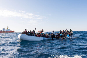
Emergency floating device for critical rescue operation. The Banana is an inflatable tube of 16 meters with ropes around deployed from the front deck of Ocean Viking and towed by the RHIB to the distress scene. Around 100 people can cling to it in the water, the time needed for the rescuers to stabilize the situation and to recover them into the RHIB.
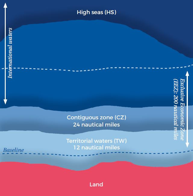
Line from which is measured the extent of States’ maritime entitlements.
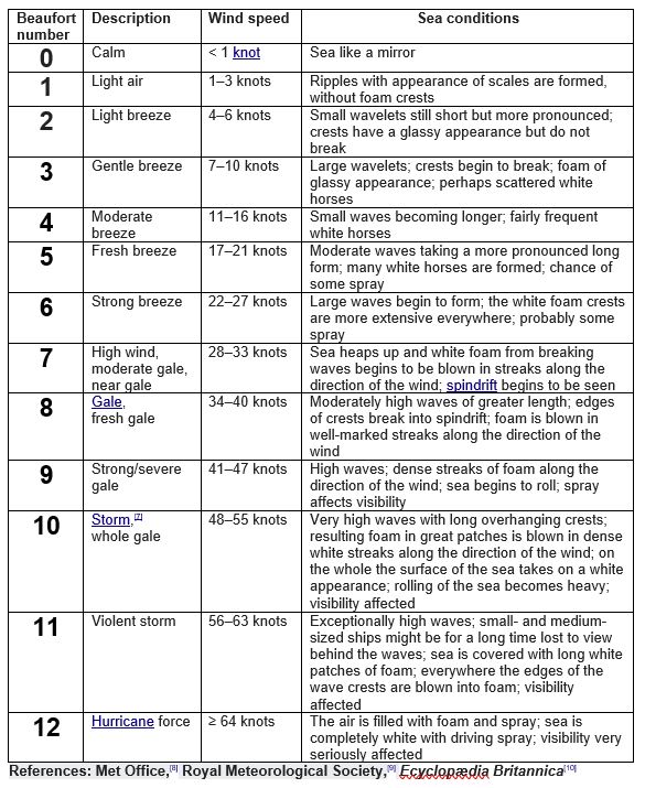
The Beaufort scale is a scale for measuring wind speed.
See below the scale.
The boat landing is a special ladder surrounded by 2 pillars which allow the RHIB to transfer people through the bow, and to be stabilized even in rough conditions. The boat landing is located in the main deck and is fitted with a hoisting system to transfer weak and injured people with a stretcher or an evacuation chair. 2 crew members stay permanently on the ladder to help survivors to climb it.
The Bouri field lies in water depths between 145m and 183m, offshore the Libyan coast, in the Mediterranean Sea. The field is located in the block NC-41, which contains one oil reservoir and two gas reservoirs.
The field is operated by ENI (30%) in partnership with state-owned National Oil Corporation (70%), with the two partners jointly setting up Mellitah Oil and Gas Company to manage the field.
Production from the field started in 1988 through two production platforms and Sloug floating storage and offloading (FSO) vessel. In 2012 it was announced that the existing FSO will be replaced by a new FSO named Gaza. Built at a cost of $424.78m, the new vessel reached the Libyan field in May 2016.
Source : https://www.offshore-technology.com/projects/bouri-field-mediterranean-sea/
Front of the ship.
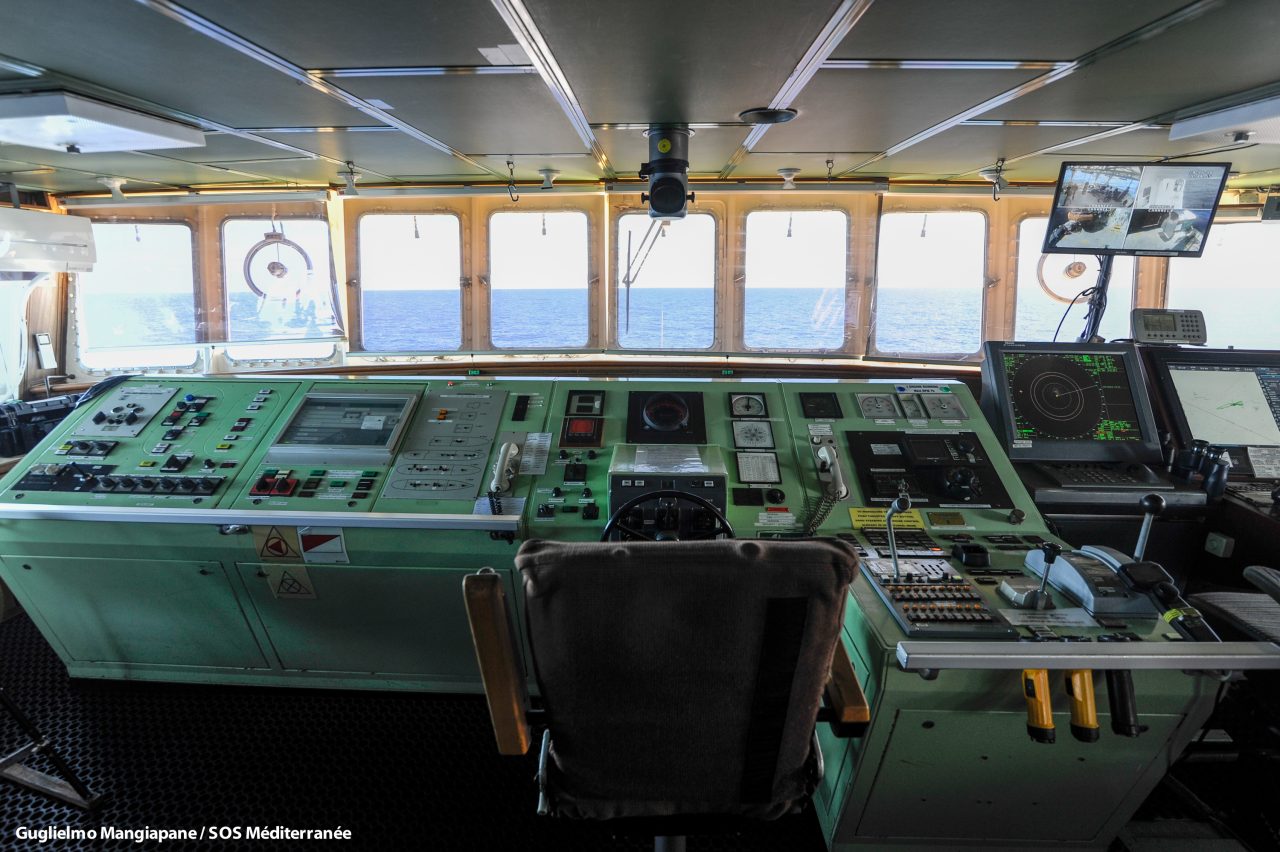
Control room from where the ship and communications are managed.
Bunkering is the supplying of fuel for use by ships
cable: A cable length or length of cable is a nautical unit of measure equal to one tenth of a nautical mile or approximately 100 fathoms. Due to anachronisms and varying techniques of measurement, a cable length can be anywhere from 169 to 220 metres, depending on the standard used. The unit is named after the length of a ship’s anchor cable in the Age of Sail.
The definition varies:
Marine VHF radio frequency designated as an international distress frequency.
Contract between the shipowner/shipmanager and the company in charge of the operations. SOS MEDITTERRANEE is the charterer of the Ocean Viking. The Ocean Viking is chartered for a certain period of time, with termination date and early-termination special clauses.
“Circomare Guardia Costiera Lampedusa” is the Italian Coast Guard based in Lampedusa
State that has sovereignty over specific territorial waters as well as sovereign rights in the contiguous zone and in the exclusive economic zone.
Colibri is an airplane (MCR 4s) operated by the association Pilotes Volontaires. Its mission is to “provide support from the air for search and rescue services at sea, helping them to locate boats in distress”. Colibri flies over the central Med area. More info : www.pilotes-volontaires.org
The person in charge of communication onboard the Ocean Viking serves a crucial role in managing media footage, coordinating with journalists onboard, and establishing communication lines in collaboration with the communication department.
Area in which a coastal state may prevent and punish infringements of its laws and regulations with regards to customs, taxation, immigration and health within its territory or territorial waters. The coastal State must declare and notify to the United Nations the existence of a CZ, in order to enjoy these powers.
Direction to where the ship goes to.
Cardiopulmonary resuscitation is a last resort intervention, for when a person is not breathing. It combines chest compressions with artifical ventilation.
Situation where the people in distress are in an unstable condition and the SAR Team has to deploy additional rescue devices to prevent a disaster. It’s under the assessment of the Deputy SAR Coordinator to activate the “Critical rescue procedure”. It happens usually when the boat is deflated, close to sink or capsize, and/or when people are already in the water.
Person in charge of the management of the SAR Team of SOS MEDITERRANEE. This person manages the trainings, the maintenance schedule, the drills, the SAR Team composition and the operations in the water.
A situation wherein there is reasonable certainty that a vessel or other craft, including an aircraft or a person, is threatened by grave and imminent danger and require immediate assistance.
The following elements allow the definition of a distress situation: (i) the existence of a request for assistance, although such a request shall not be the sole factor for determining the existence of a distress situation; (ii) the seaworthiness of the vessel and the likelihood that the vessel will not reach its final destination; (iii) the number of persons on board in relation to the type and condition of the vessel; (iv) the availability of necessary supplies such as fuel, water and food to reach a shore: (v) the presence of qualified crew and command of the vessel; (vi) the availability and capability of safety, navigation and communication equipment; (vii) the presence of persons on board in urgent need of medical assistance; (viii) the presence of deceased persons on board; (ix) the presence of pregnant women or of children on board; (x) the weather and sea conditions, including weather and marine forecasts.
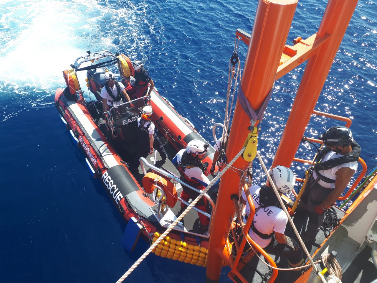
One of the rescue RHIB onboard MV Ocean Viking with a capacity of 20 to 25 people, twin 115 horsepower engine, 7 meters length. This RHIB is stored in the upper starboard side deck and deployed/recovered with a dedicated davit. The crew is composed with 1 driver, 1 boat leader, 2 crew members and 1 medical staff (usually a nurse). This RHIB is usually used for providing lifejackets and to perform evacuation and shuttles to the MV Ocean Viking.
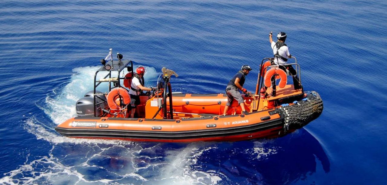
One of the rescue RHIB onboard Ocean Viking with a capacity of 15 to 20 people, 175 horsepower engine, 6,5 meters length. This RHIB is stored in the main deck and deployed/recovered with the main cargo crane. The crew is composed with 1 driver, 1 boat leader, 1 crew member and 1 cultural mediator. This RHIB is usually used as the first approach for crowd control, the distribution of lifejackets and for the deployment of mass rescue devices. When The situation is stabilized, Easy 2 can be used for shuttling people from the boat in distress into the Ocean Viking.
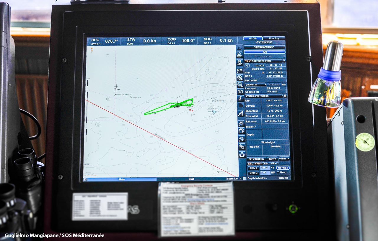
Electronic Chart Display and Information Systems :
Ships have long been required to carry nautical charts and nautical publications to plan and display the ship’s route for the intended voyage and to plot and monitor positions throughout the voyage.
The advent of electronic charts in the 1990s provided ships with additional information, including real time information which could be displayed on screens on Electronic Chart Display and Information Systems (ECDIS).
More information here : http://www.imo.org/en/OurWork/Safety/Navigation/Pages/ElectronicCharts.aspx
Enhanced Group Call :
Excerpt from the GMDSS Manual:
3.7.9 The EGC system, which was developed by Inmarsat, enables the provision of uniaue global automated service capable of adressing messages to pre-determined groups of ships or all vessels in both fixed and variable geographical areas.
A generic term meaning, as the case may be, uncertainty phase, alert phase or distress phase.
Expected Time of Arrival
Estimated Time of Departure
European military operation, also called “operation Sophia”, launched in May 2015 and deployed in the central Mediterranean Sea, with the following missions :
“Training of the Libyan coastguards and navy; to contribute to the implementation of the UN arms embargo on the high seas off the coast of Libya according to UNSCR 2292 (2016) and UNSCR 2357 (2017); to set up a monitoring mechanism of the long-term efficiency of the training of the Libyan Coastguard and Navy; to conduct new surveillance activities and gather information on illegal trafficking of oil exports from Libya in accordance UNSCR 2146 (2014) and 2362 (2017); to enhance the possibility for sharing information on human trafficking with member states law enforcement agencies, FRONTEX and EUROPOL.”
Source : https://eur-lex.europa.eu/legal-content/EN/TXT/?uri=CELEX%3A32017D1385 / http://www.consilium.europa.eu/en/press/press-releases/2016/06/20/fac-eunavfor-med-sophia/
Area where the coastal State has exclusive rights over the natural resources. However the State must respect the high seas freedom of navigation.
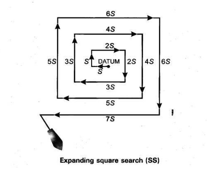
A search pattern used when the last known position of a search object has a high degree of accuracy, the search area is small, and a concentrated search is desirable.
The flag state of a merchant vessel is the jurisdiction under whose laws the vessel is registered or licensed, and is deemed the nationality of the vessel. A merchant vessel must be registered and can only be registered in one jurisdiction, but may change the register in which it is registered. The flag state has the authority and responsibility to enforce regulations over vessels registered under its flag, including those relating to inspection, certification, and issuance of safety and pollution prevention documents. As a ship operates under the laws of its flag state, these laws are applicable if the ship is involved in an admiralty case.
Ocean Viking is registered by the Norwegian Maritime Authority.
| FPSO: A floating production storage and offloading (FPSO) unit is a floating vessel used by the offshore oil and gas industry for the production and processing of hydrocarbons, and for the storage of oil. |
Height between the water surface and the main deck of the ship.
European Border and Coast Guard Agency. The aim of this EU agency is to “help EU countries and Schengen associated countries manage their external borders”. Among other elements, “it coordinates maritime operations and the deployment of additional technical equipment (e.g. aircraft and boats) and specially-trained border staff” at EU external borders.
More info: https://europa.eu/european-union/about-eu/agencies/frontex_en
The General Administration for Costal Security (GACS) is a Law Enforcement entity established within the structure of the Minister of Interior of Libya and headed by a Director General.
(Source: Council of the European Union / European External Action Service / EUBAM Libya Initial Mapping Report Executive Summary 25 January 2017, p.38).
Global Integrated Shipping Information System
Website of the International Maritime Organisation (IMO) that contains, among other elements, the Global SAR Plan (providing information on the availability of Search and Rescue (SAR) Service).
Global Maritime Distress and Safety System:
A global communications service based upon automated systems, both satellite-based and terrestrial, to provide distress alerting and promulgation of maritime safety information for mariners.
More info :
http://www.imo.org/en/OurWork/Safety/Regulations/Documents/GMDSSandSAR1999.pdf/
Global Positioning System
A specific satellite-based radio navigation system in conjunction with mobile equipment to determine the precise position of the mobile equipment.
Direction to where the ship heads to.
Areas which are not subject to the sovereignty of any State.
International Aeronautical and Maritime Search and Rescue :
IMO guidelines for a common aviation and maritime approach to organizing and providing search and rescue (SAR) services. The IAMSAR Manual comprises three volumes, each with specific search and rescue (SAR) system duties in mind, and can be used as a stand-alone document or in conjunction with the other two volumes as a means to attain a full view of the SAR system.
International Maritime Organisation :
United Nations specialized agency with responsibility for the safety and security of shipping and the prevention of marine and atmospheric pollution by ships. IMO’s work supports the UN SDGs.
A system of geostationary satellites for world-wide mobile communications services and which support the GMDSS and other emergency communication systems.
As indicated under article 19 of the Montego Bay Convention, a “passage is innocent so long as it is not prejudicial to the peace, good order or security of the coastal State”.
Any body of water situated beyond 12 nautical miles from the baseline – outside the territorial waters of a state. Not subject to the sovereignty of any State.
International Organisation for Migration :
Established in 1951, IOM is the leading inter-governmental organization in the field of migration and works closely with governmental, intergovernmental and non-governmental partners.
With 172 member states, a further 8 states holding observer status and offices in over 100 countries, IOM is dedicated to promoting humane and orderly migration for the benefit of all. It does so by providing services and advice to governments and migrants.
IOM works to help ensure the orderly and humane management of migration, to promote international cooperation on migration issues, to assist in the search for practical solutions to migration problems and to provide humanitarian assistance to migrants in need, including refugees and internally displaced people.
The IOM Constitution recognizes the link between migration and economic, social and cultural development, as well as to the right of freedom of movement.
Italian Coast Guards :
Italian maritime authority, responsible for the Italian SAR Service
Italian Rescue Coordination Center (MRCC Rome)
Shipping company in charge of the management of Aquarius, including the certification of the ship, part of the insurance, the management of the bunkering, the management of the catering, the management of the engine, bridge and accommodation maintenance, and the management of the navigation. http://www.jasmund-shipping.de/
Joint Rescue Coordination Center
Nautical speed, in Nautical miles per hour. 1 Knot = 1,852 km/h.
Distance from the equator in degrees.
LNCG
Libyan maritime authority, responsible for the Libyan SAR Service according to the Global SAR Plan of the IMO.

Individual floating device which keep the body floating and the head out of the water. This can be automatic inflatable lifejacket for the SAR Team, or foam lifejacket for the survivors.
A liferaft is a self- inflatable emergency evacuation device. It is usually used by ships in case the crew and passengers have to abandon the ship. The Ocean Viking is also equipped with small emergency liferafts that can be embarked embarked onboard the RIBs, ready to be deployed at any time in case of critical rescue.
Libyan Navy & Coast Guards
Libyan maritime authority, responsible for the Libyan SAR Service according to the Global SAR Plan of the IMO.
Shortest distance from the Greenwich meridian in degrees.
Libyan JRCC in Tripoli
Deck in the aft part of the ship, where are the reception facilities for survivors and where Easy 2 is stored.
Deck in the aft part of the ship, where the reception facilities for survivors are.
Mass Casualty Plan :
A situation where there is more than 1 unconscious person to resuscitate. In this case, all the crew is mobilized, the shelter room is used as an emergency room.
Medical Evacuation: Life-saving technique based on timely transport and en route medical care of injured or ill persons to a better-equipped treatment facility
Maritime Mobile Service Identity number :
All vessels operating on the high seas require a Maritime Mobile Service Identity (MMSI) number to participate in the Global Maritime Distress & Safety System (GMDSS). In addition to GMDSS participation the MMSI number also serves as a unique identifier of the vessel for all communications. As the international governing body for telecommunications the International Telecommunications Union (ITU) has set the international conventions for the use of MMSI numbers. MMSI number is a 9-digit code issued by the host country agency for use in VHF marine radio equipment, AIS transponders, EPIRB’s, and all INMARSAT satellite terminals.
Airplane conducting a civil aerial reconnaissance mission, run together by Sea-Watch and the Humanitarian Pilots Initiative. It regularly flies over the central Mediterranean sea, searching for potential boats in distress. More info: https://sea-watch.org/en/project/moonbird/
Maritime Rescue Coordination Center
An RCC dealing with maritime SAR incidents.
Mass Rescue Operation :
A mass rescue operation (MRO) is one that involves the need for immediate assistance to large numbers of persons in distress such that capabilities normally available to search and rescue (SAR) authorities are inadequate. (Source : COMSAR/Circ.31 : https://international-maritime-rescue.org/sar-operations/file/516-comsar-circ-31-guidance-for-mass-rescue-operations)
Maltese JRCC in Valetta
Nautical distance, 1 minute of latitude. 1 Nm = 1,852 km
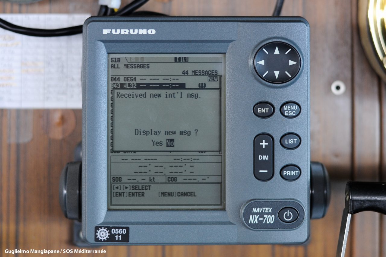
NAVTEX provides shipping with navigational and meteorological warnings, meteorological forecasts and other urgent safety-related messages by automatic display or printout from a dedicated receiver. It is suitable for use in all sizes and types of ships.
More info here : https://www.myseatime.com/blog/detail/20-navtex-question-and-answers-to-make-naxtex-your-friend-for-life
Parties shall ensure that assistance be provided to any person in distress at sea. They shall do so regardless of the nationality or status of such a person or the circumstances in which that person is found.
OSV
These are cargo vessels that regularly transport goods, supplies or equipment in support of exploration or production of offshore mineral or energy resources. Offshore supply vessels are typically operated by shipowners: either companies set up specifically to own and operate such vessels or companies combine with other vessel operations like salvage, shipping, etc.
The OSVs can be divided into a number of types according to the operations they perform: seismic survey ships, platform supply vessels (PSV), anchor handling tugs, anchor handling tug and supply vessels (AHTS), offshore construction vessels (OCV), ROV support vessels, dive support vessels, stand-by vessels, inspection, maintenance and repair vessels (IMR) and variety of combinations of these.
at the site of an incident
MV Open Arms (IMO: 7325887, MMSI 224772000) of the Spanish NGO Proactiva Open Arms. Spanish flag. length 37m, width 9.5m, 427 GT. More info: https://www.openarms.es/en
Aerial maritime operation launched in March 2015 by Italy’s Ministry of Defense, to “ensure maritime presence, surveillance and safety in the central Mediterranean and the Strait of Sicily”. Since 2017, Italy extended the operation into Libyan territorial waters “in order to be able to carry out support activities for the Libyan Coast Guard and Navy in the fight against illegal maritime trafficking, if requested by the Libyan counterpart.”
Source: http://www.marina.difesa.it/cosa-facciamo/operazioni-in-corso/Pagine/MareSicuro.aspx
Frontex (EU Border and Coast Guard Agency) operation launched in February 2018 to “assist Italy in border control activities” in the Central Mediterranean “with an enhanced law enforcement focus”. Replacing the “Triton” operation launched in 2014.
On-Scene Coordinator:
A person designated to co-ordinate SAR operations within a specified area.
The Paris Memorandum of Understanding (MoU) on Port State Control is the official document in which 27 participating Maritime Authorities agree to implement a system of Port State Control.
The current member States of the Paris MoU are:
Belgium, Bulgaria, Canada, Croatia, Cyprus, Denmark, Estonia, Finland, France, Germany, Greece, Iceland, Ireland, Italy, Latvia, Lithuania, Malta, the Netherlands, Norway, Poland, Portugal, Romania, the Russian Federation, Slovenia, Spain, Sweden and the United Kingdom
Mission is to eliminate the operation of sub-standard ships through a harmonized system of Port State control.
Annually more than 18.000 inspections take place on board foreign ships in the Paris MoU ports, ensuring that these ships meet international safety, security and environmental standards, and that crew members have adequate living and working conditions.
Basic principle is that the prime responsibility for compliance with the requirements laid down in the international maritime conventions lies with the shipowner/operator.
Responsibility for ensuring such compliance remains with the flag State.
Info: http://www.parismou.org/system/files/Paris%20MoU%2C%20including%2041st%20amendment.pdf
Situation when the Ocean Viking is standing-by or/and moving at slow speed in an area where distresses are highly probable. In general, during this period, the SAR Team stays on watch on the bridge with the help of radars and binoculars.
The vessel’s navigator. An especially knowledgeable person qualified to navigate a vessel through difficult waters, e.g. harbour pilot etc.
Location where rescue operations are considered to terminate. It is also a place where the survivors’ safety of life is no longer threatened and where their basic human needs (such as food, shelter and medical needs) can be met. Further, it is a place from which transportation arrangements can be made for the survivors’ next or destination.
An assisting ship should not be considered a place of safety based solely on the fact that the survivors are no longer in immediate danger once aboard the ship. An assisting ship may not have appropriate facilities and equipment to sustain additional persons on board without endangering its own safety or to properly care for the survivors. Even if the ship is capable of safely accommodating the survivors and may serve as a temporary place of safety, it should be relieved of this responsibility as soon as alternative arrangements can be made.
A place of safety may be on land, or it may be aboard a rescue unit or other suitable vessel or facility at sea that can serve as a place of safety until the survivors are disembarked to their next destination.
The Conventions, as amended, indicate that delivery to a place of safety should take into account the particular circumstances of the case. These circumstances may include factors such as the situation on board the assisting ship, on scene conditions, medical needs, and availability of transportation or other rescue units. Each case is unique, and selection of a place of safety may need to account for a variety of important factors.
Governments should co-operate with each other with regard to providing suitable places of safety for survivors after considering relevant factors and risks.
The need to avoid disembarkation in territories where the lives and freedoms of those alleging a well-founded fear of persecution would be threatened is a consideration in the case of asylum-seekers and refugees recovered at sea.
Number of persons onboard
Ships and the ship’s captain approach a port agency to make sure that proper mooring areas are allotted to the ship and all the pertaining documents are ready and adequately taken care of. Additionally, port agencies also mention all minor and major aspects about the charges of customs and all other government procedures required to be fulfilled by the captain of the ship.
A government body (city, county or state) which in international shipping maintains various airports and/or ocean cargo pier facilities, transit sheds, loading equipment warehouses for air cargo, etc. Has the power to levy dockage and wharfage charges, landing fees, etc.
Port State Control (PSC) is an inspection regime for countries to inspect foreign-registered ships in port other than those of the flag state and take action against ships that are not in compliance.
Such inspectors are called PSC officers, and are required to investigate compliance with the requirements of international conventions, such as SOLAS, MARPOL, STCW, and the MLC. Inspections can involve checking that the vessel is manned and operated in compliance with applicable international law, and verifying the competency of the ship’s master and officers, and the ship’s condition and equipment.
Place of Safety :
Location where rescue operations are considered to terminate. It is also a place where the survivors’ safety of life is no longer threatened and where their basic human needs (such as food, shelter and medical needs) can be met. Further, it is a place from which transportation arrangements can be made for the survivors’ next or destination.
An assisting ship should not be considered a place of safety based solely on the fact that the survivors are no longer in immediate danger once aboard the ship. An assisting ship may not have appropriate facilities and equipment to sustain additional persons on board without endangering its own safety or to properly care for the survivors. Even if the ship is capable of safely accommodating the survivors and may serve as a temporary place of safety, it should be relieved of this responsibility as soon as alternative arrangements can be made.
A place of safety may be on land, or it may be aboard a rescue unit or other suitable vessel or facility at sea that can serve as a place of safety until the survivors are disembarked to their next destination.
The Conventions, as amended, indicate that delivery to a place of safety should take into account the particular circumstances of the case. These circumstances may include factors such as the situation on board the assisting ship, on scene conditions, medical needs, and availability of transportation or other rescue units. Each case is unique, and selection of a place of safety may need to account for a variety of important factors.
Governments should co-operate with each other with regard to providing suitable places of safety for survivors after considering relevant factors and risks.
The need to avoid disembarkation in territories where the lives and freedoms of those alleging a well-founded fear of persecution would be threatened is a consideration in the case of asylum-seekers and refugees recovered at sea.
Person in charge of the management of the mission for MSF.
Food and non-food items necessary for the crew to live in autonomy for several days and weeks onboard the ship.
PSC (Port State Control) is an inspection regime for countries to inspect foreign-registered ships in port other than those of the flag state and take action against ships that are not in compliance.
Such inspectors are called PSC officers, and are required to investigate compliance with the requirements of international conventions, such as SOLAS, MARPOL, STCW, and the MLC. Inspections can involve checking that the vessel is manned and operated in compliance with applicable international law, and verifying the competency of the ship’s master and officers, and the ship’s condition and equipment.
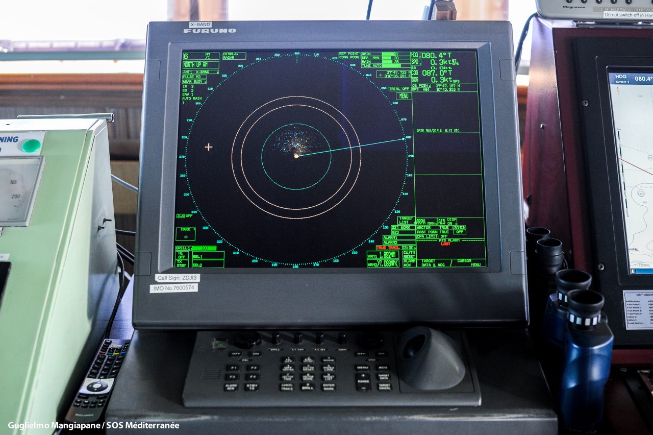
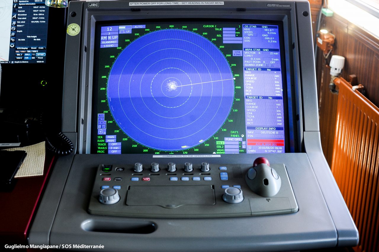
Detection system that uses radio waves to determine the range, angle, or velocity of objects. It can be used to detect aircraft, ships, spacecraft, guided missiles, motor vehicles, weather formations, and terrain. A radar system consists of a transmitter producing electromagnetic waves in the radio or microwaves domain, a transmitting antenna, a receiving antenna (often the same antenna is used for transmitting and receiving) and a receiver and processor to determine properties of the object(s). Radio waves (pulsed or continuous) from the transmitter reflect off the object and return to the receiver, giving information about the object’s location and speed.
Inflatable raft used by the SAR Team as emergency floating device during critical rescue operations.
Person in charge of the collection, treatment, archiving and publication of all the information related to SAR and maritime operations of Ocean Viking. This person is regularly on the bridge, together with the SAR Coordinator.
Action to provide with a fresh supply of food and non-food items.
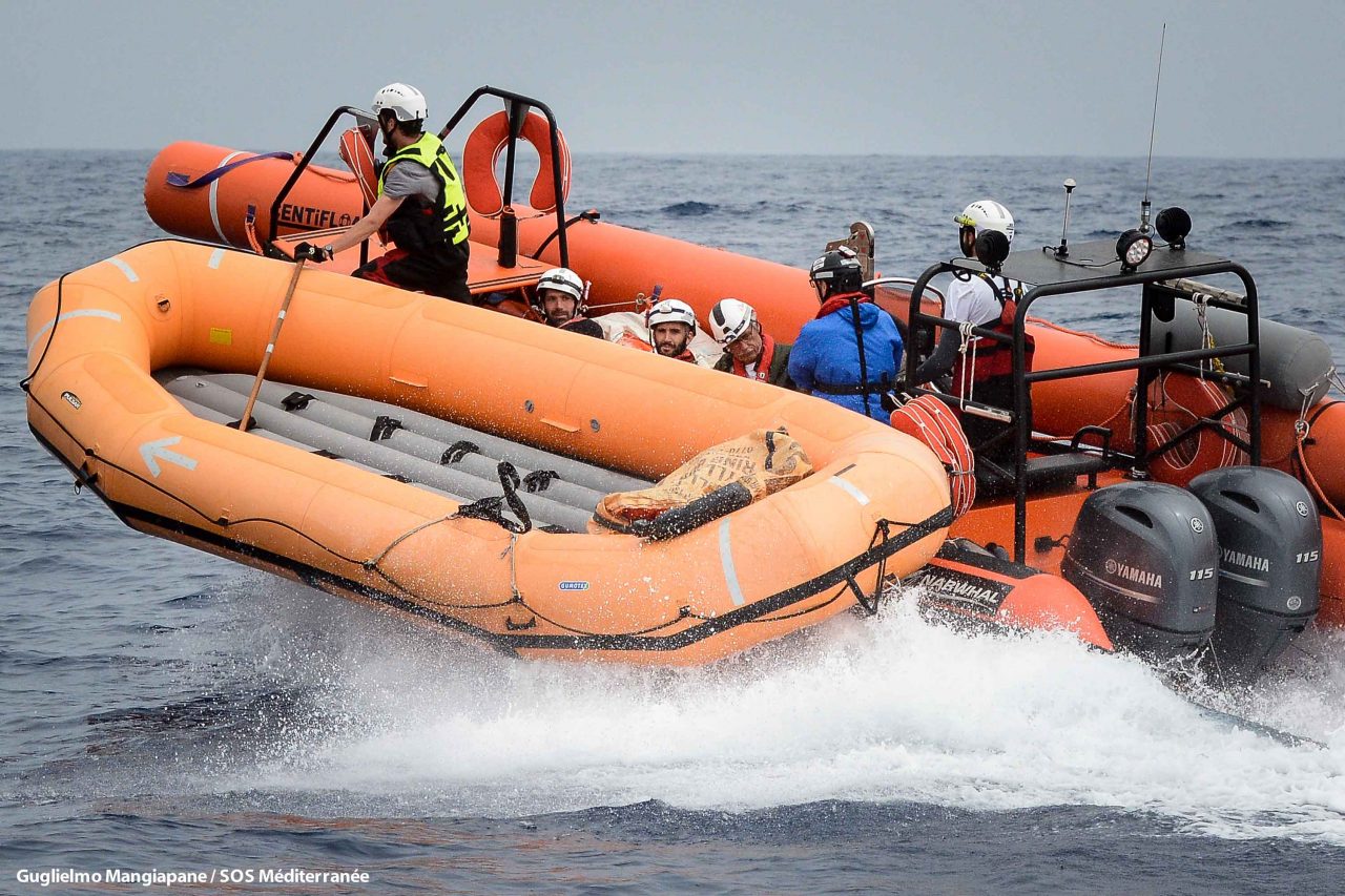
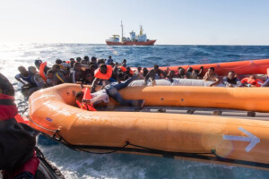
Rigid-Hulled Inflatable Boat :
Boat with rigid hull and inflatable tubes around the hull, generally with outboard engine.
The Ocean Viking is equipment with 3 RIBs:
Narwal SP70 – 2x115hp
Sillinger Proraid 650 – 175hp
Zodiac Mark V – 60hp
Rigid Inflatable Boat :
Boat with rigid hull and inflatable tubes around the hull, generally with outboard engine.
The Ocean Viking is equipment with 3 RIBs:
Narwal SP70 – 2x115hp
Sillinger Proraid 650 – 175hp
Zodiac Mark V – 60hp
The Ocean Viking makes regular stops in port to refuel, to change the crew, for the maintenance of the equipment, for the restock of the rescue kits and the provisions and for meeting with the managers to discuss about the strategy. A rotation starts during these stops in port and ends during the next stop in port. It can be between 20 and 30 days.
Search And Rescue :
Search: An operation, normally co-ordinated by a rescue coordination center or rescue sub-center, using available personnel and facilities to locate persons in distress.
Rescue An operation to retrieve persons in distress, provide for their initial medical or other needs, and deliver them to a place of safety; (Source: SAR Convention 1979, Chapter 1.3.1-2 http://opac.vimaru.edu.vn/edata/EBook/Sar%20Convention,%201979.pdf)
Reference number of the SAR operation designated by the RCC in charge. There is one SAR Case number for each boat in distress or potentially in distress.
Every survivor is affiliated to a SAR Case until their disembarkation to a place of safety, corresponding to the boat in distress they have been rescued from.
= International Convention on Maritime Search and Rescue (SAR or Hamburg Convention)
It was adopted under IMO auspices on 27th April 1979 and entered into force on 22nd June 1985. It has 111 State Parties and its purpose is not only to enable cooperation and coordination of State actions in terms of rescue at sea but also to “encourage cooperation between search and rescue organizations worldwide and between all those who take part in search and rescue operations at sea”.
Person in charge of the management of the mission for SOS MEDITERRANEE. This person is regularly on the bridge, together with the Captain, to oversee the operations, to take decisions, to coordinate the teams and other assets and to communicate with the SAR authorities.
State which is responsible for the search and rescue of persons using its services and equipment within the SAR area.
Team composed by 9 professional seafarers and rescuers, part of SOS MEDITERRANEE. They are in charge of the RIBs and the deployment of the floating devices.
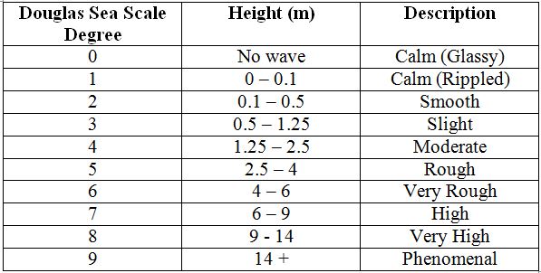
General condition of the surface of the open sea.
The state of the sea is described using the Douglas scale.
There are actually two scales; one to measure the wind waves (caused by the wind in the local area) and one to measure the swell (longer flatter waves attributable to previous or distant winds).
Below is the Douglas scale for the wind waves.
MV Sea-Watch 3 (IMO: 7302225, MMSI: 211281610) of the German NGO Sea-Watch. German Flag. Length 50m, width 12m, 645 GT. More info: https://sea-watch.org/en/
An area of defined dimensions, associated with aRCC, within which SAR services are provided.
Area at sea protected from the weather to leeward from the coast line
Situation Report :
It gives information about on-scene mission progress and conditions. SITREPs are used by SAR facilities to keep OSC informed, by OSC to keep SMC informed and by SMC to keep superiors, RCCs and RSCs informed.
SAR Mission Coordinator
The official temporarilyassigned to coordinate response to an actual or apparent distress situation.
Safety Of Life At Sea
The SOLAS Convention in its successive forms is generally regarded as the most important of all international treaties concerning the safety of merchant ships. The first version was adopted in 1914, in response to the Titanic disaster, the second in 1929, the third in 1948, and the fourth in 1960. The 1974 version includes the tacit acceptance procedure – which provides that an amendment shall enter into force on a specified date unless, before that date, objections to the amendment are received from an agreed number of Parties.
The main objective of the SOLAS Convention is to specify minimum standards for the construction, equipment and operation of ships, compatible with their safety. Flag States are responsible for ensuring that ships under their flag comply with its requirements, and a number of certificates are prescribed in the Convention as proof that this has been done. Control provisions also allow Contracting Governments to inspect ships of other Contracting States if there are clear grounds for believing that the ship and its equipment do not substantially comply with the requirements of the Convention – this procedure is known as port State control. The current SOLAS Convention includes Articles setting out general obligations, amendment procedure and so on, followed by an Annex divided into 14 Chapters.
= International Convention for the Safety of Life at Sea (SOLAS or London Convention)
This text was adopted under IMO auspices on 1st November 1974 and came into force on 25th May 1980. It includes 121 State Parties. It imposes important obligations to States in terms of search and rescue. In particular they are committed to monitoring coasts and supplying any information regarding their own rescue means.
Spanish MRCC in Madrid
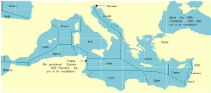
Search and Rescue Region
At the bottom of the chart, in light green, the Libyan SRR, above that, in pink, the Maltese one, and above the Maltese one, just overlapping with the Maltese SRR, the Italian one.
Ship Security Alert System :
Excerpt from the GMDSS Manual :
3.9.1 […] The SSAS is fitted to a ship for the purpose of trans;itting a security alert to the shoreto indicate to a competent authority that the security of the ship is under threat or has been compromised.
Offical term to designate the people rescued from a distress situation.
Object in the water surface or in the radar screen. Onboard the Ocean Viking, the SAR Team calls any potential boat in distressa “target”.
Belt of coastal waters extending at most 12 nautical miles from the baseline (usually the mean low-water mark) of a coastal state. The territorial sea is regarded as the sovereign territory of the state, although foreign ships (civilian) are allowed innocent passage through it, or transit passage for straits; this sovereignty also extends to the airspace over and seabed below. Adjustment of these boundaries is called, in international law, maritime delimitation.
A time charter – is a contract for the hire of a named vessel for a specified period of time. – may be thought of as equivalent to the hire of a chauffeur-driven car (the ship’s crew being “the chauffeur”).
A general purpose dry cargo time charter party will usually incorporate clauses covering at least the basic provisions tabulated below. The provisions may be covered in different charter parties by clauses bearing different names, or by numbered clauses without names.
Tunisian MRCC in Tunis
Transfer of rescued people between two ships. This can be done by RIBs, or alongside.
Operation of transferring people or material from a ship to another.
A small vessel designed to tow or push large ships or barges. Tugs have powerful diesel engines and are essential to docks and ports to manoeuvre large ships into their berths.
Oceangoing salvage tugs provide assistance to ships in distress and engage in such work as towing drilling rigs and oil production platforms.
A situation wherein doubt exists as to the safety of an aircraft or a marine vessel, and of the persons onboard.
= United Nations Convention on the Law of the Sea (UNCLOS).
The UNCLOS was adopted on 10th December 1982 and came into force on 16th November 1994. It defines and delimits maritime spaces, rights and obligations of the States over these areas, specifically those relating to navigation, use of natural resources and protection and preservation of the marine environment. It also created the International Tribunal for the Law of the Sea (ITLOS), a tribunal which is competent to hear any dispute regarding the interpretation and application of the UNCLOS.
A ship is underway when she is in movement towards a direction/destination or drifting. A ship is not underway when she is in port, at anchor or grounded
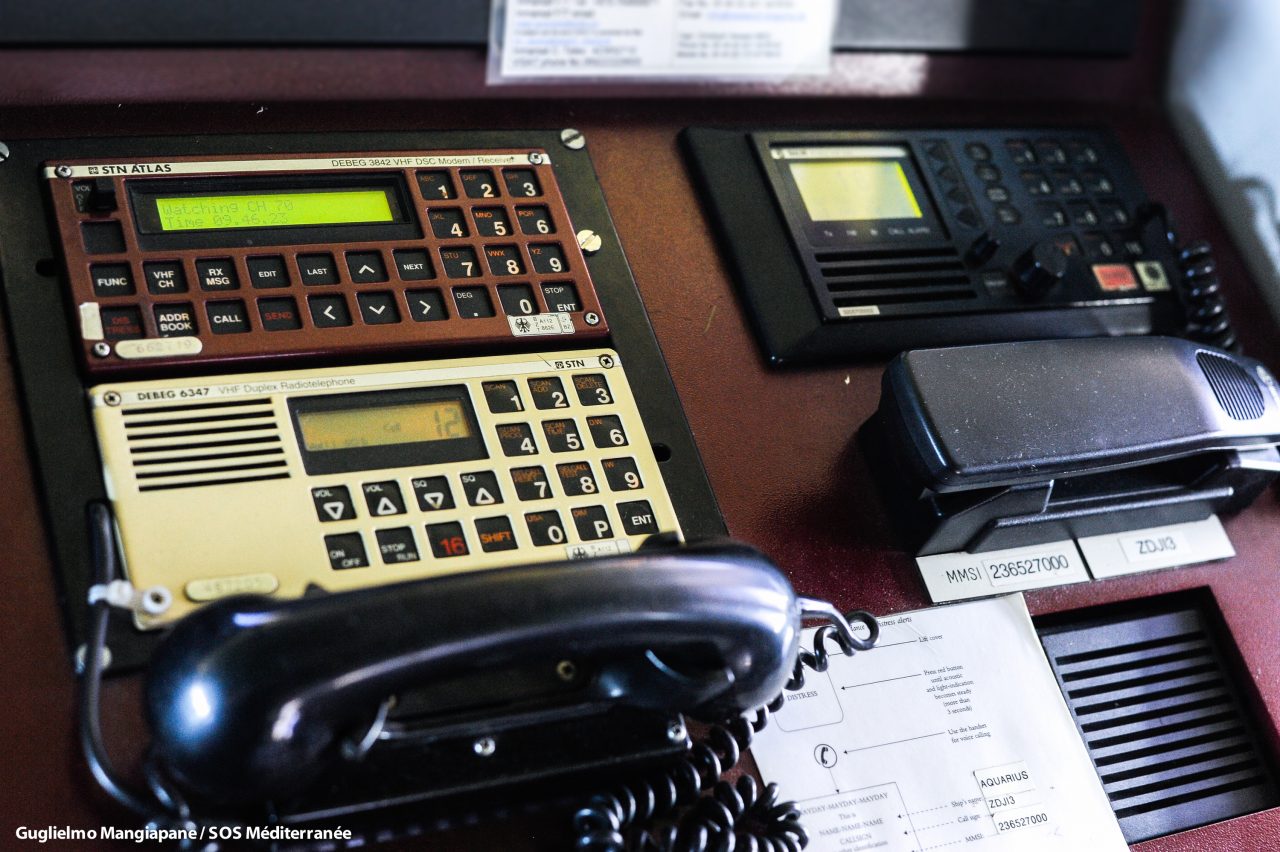
Very High Frequency :
ITU designation for the range of radio frequency electromagnetic waves (radio waves) from 30 to 300 megahertz (MHz), with corresponding wavelengths of ten to one meter. Frequencies immediately below VHF are denoted high frequency (HF), and the next higher frequencies are known as ultra high frequency (UHF).
Common uses for VHF are FM radio broadcasting, television broadcasting, two way land mobile radio systems (emergency, business, private use and military), long range data communication up to several tens of kilometers with radio modems, amateur radio, and marine communications. Air traffic control communications and air navigation systems (e.g. VOR & ILS) work at distances of 100 kilometers or more to aircraft at cruising altitude.